Student Climate Blog Series: Exploring Municipal Impacts of Highway 413, Part 1
(6 April 2022) by Relina D’Cruz
This blog post is the first of a two-part series focussing on the municipal impacts of the highly controversial proposed Highway 413. The series will address interjurisdictional tensions between relevant municipalities and the province of Ontario by highlighting competing interests related to land use planning and development. This first post outlines the proposal for Highway 413, public and environmental concerns about its construction, and the municipalities through which it would run. The second post will then discuss how the municipalities to be directly affected by the proposed construction of Highway 413 have responded, with a focus on the municipalities of Peel Region.
What is Highway 413?
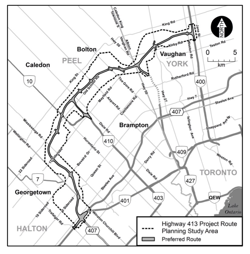
Highway 413, also referred to as the GTA West Corridor, is a proposed 400 series highway in the western Greater Toronto Area (“GTA”). The Liberal government initially considered this provincial project in the early 2000s as a way to solve the GTA’s overwhelming traffic congestion problem. When the Wynne government came into power in 2013, these provincial plans were shut down. However, with the election of Doug Ford as Premier in 2018 the idea was re-introduced with promises to reduce overall traffic and create more jobs for people in the GTA. Highway 413 would be a 59-kilometre highway and is expected to have four to six lanes, with connections to Highways 427, 400, 410, 401 and 407 ER. It would extend from Highway 400, between King Road and Kirby Road in Vaughan, to the 401/407 ETR interchange near Mississauga, Milton and Halton Hills.
Why is Highway 413 controversial?
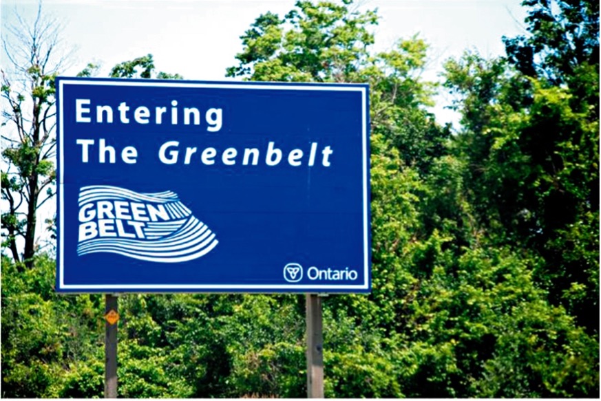
While there are a few concerns associated with the construction of Highway 413. A major issue surrounds its environmental impacts. Highway 413 will cross the Greenbelt, a legislatively-protected zone designated to remain undeveloped in its natural agricultural state. Highway 413 will pave over “2000 acres of farmland, cutting through 85 waterways, damage 220 wetlands and disrupt the habitats of 10 species-at-risk.” At a time where addressing climate change should be top priority, critics argue that Highway 413 will encourage the use of automobiles. Environmental Defence estimates that the highway will ultimately “add over 17 million tonnes of greenhouse gas emissions by 2050 resulting in more than $1.4 billion in damages from that pollution.” Furthermore, in its “Stop the 413” campaign, the organization has noted that “Highway 413 would bisect the sensitive headwaters of four watersheds within Mississauga of the Credit First Nation’s territory and impact their physical and cultural heritage, including ceremonial sites, burial sites, and the cultural landscape.”
Who is responsible for Highway 413?
As per section 92 of the Canadian Constitution, matters relating to the planning, design and construction of highways generally fall within exclusive provincial jurisdiction. Powers delegated to municipalities by the province under the Ontario Municipal Act include responsibility for city roads and streets. Land-use planning is shared between the province and the municipalities: while the province lays the ground rules through the Planning Act, most implementation happens at the municipal level through official plans and land use planning decisions “to achieve their communities’ economic, social and environmental concerns.” This jurisdictional divide complicates the Highway 413 matter because while Highway 413 is a provincial highway, it is designed to run across the regional municipalities of York, Peel and Halton, as well as the cities, towns and townships comprised within them, and may impact land use planning decisions in these regions.
What municipalities will be affected by Highway 413?
Municipalities within Ontario are categorized into three types of municipalities: (1) Upper Tier (2) Lower Tier (3) Single Tier. Regions and counties are referred to as “upper tier” municipalities and provide services such as: arterial roads; transit; policing; sewer and water systems; waste disposal; region-wide land use planning and development; as well as health and social services. Each upper-tier municipality encompasses at least two lower-tier municipalities. While lower-tier municipalities are given the power to make their own decisions, this power is limited in scope because decisions must align with regional decisions.
The proposed highway route runs through the regional (upper-tier) municipalities of York, Peel and Halton. These each encompass several lower-tier municipalities. The municipality of Halton includes the City of Burlington, Town of Halton Hills, Town of Milton and Town of Oakville. The municipality of Peel includes the Cities of Brampton and Mississauga and the Town of Caledon. The municipality of York includes the Cities of Markham, Richmond Hill, and Vaughan; Towns of Aurora, East Gwillimbury, Georgina, Newmarket, and Whitchurch-Stouffville; and the Township of King.
Highway 413 will impact all of these municipalities. Blog post two of this series will discuss how municipalities have engaged with the province’s Highway 413 planning on aspects that will affect municipalities directly. Since a large portion of the proposed route runs through the regional municipality of Peel, it will focus specifically on the municipalities of Brampton, Mississauga and Caledon.
Relina D’cruz is a second-year Windsor Law student and student member of the Windsor Law Cities and Climate Action policy clinic. She lives in Brampton.
The research support of Miranda Baksh and Divya Arora of the Community Climate Council is gratefully acknowledged.
Related Articles
Launch of C4C Housing Systems & Innovation Lab
(19 December 2023) The Centre for Cities is pleased to announce the launch of its Housing Systems and Innovation Lab,…
C4C City Building: The First Four Years of the Centre for Cities
(19 December 2023) Read the full report It is our pleasure to present this report on the first four years…

AM800 Citybuilding: State of Canada’s Cities Summit & Report Launch with Anneke Smit
(29 November 2023) On today's AM800 Citybuilding segment with host Dan MacDonald, Centre for Cities' Director Anneke Smit spoke on…