Blog Series: Exploring the potential of Additional Dwelling Units (ADUs), Part 2
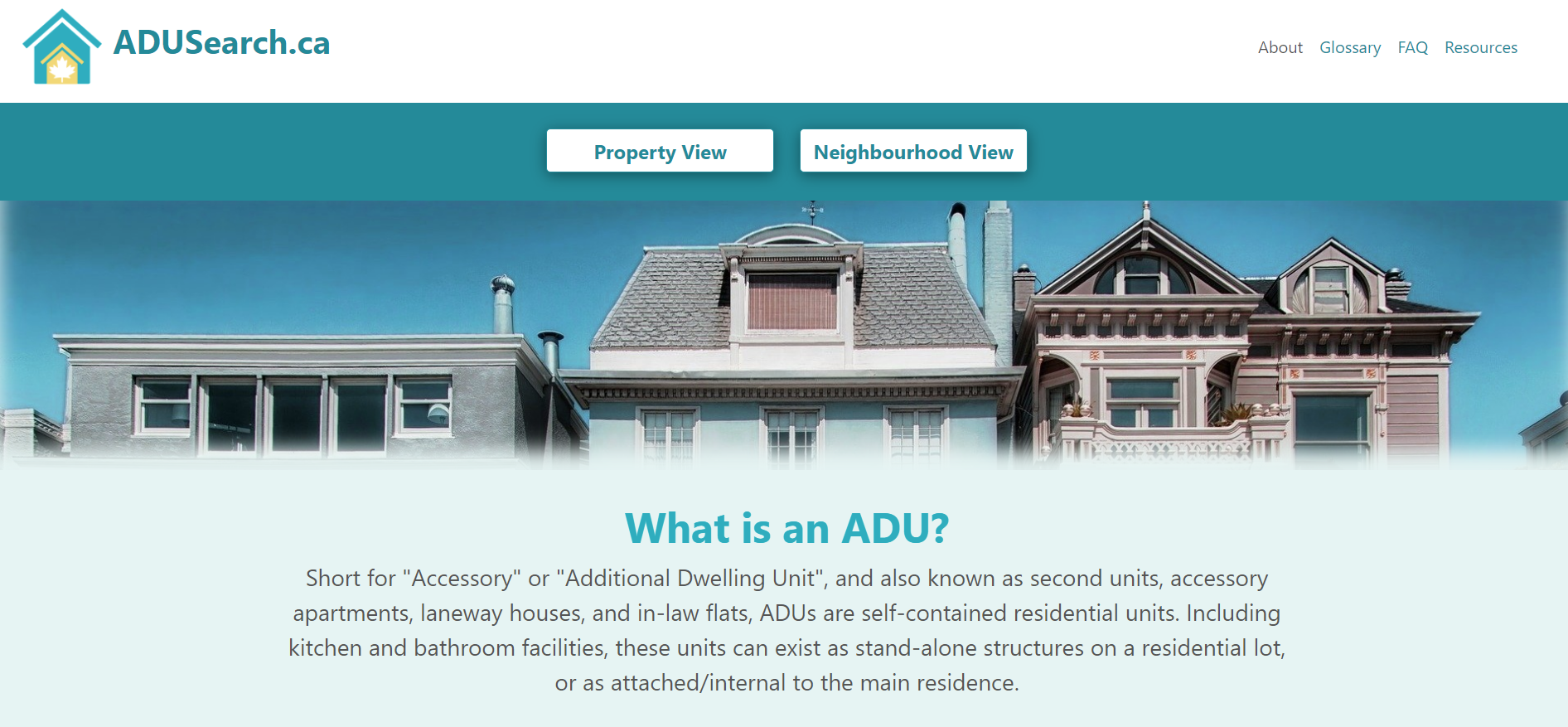
A new online tool for affordable housing development: ADUSearch.ca
(8 February 2022) By Sarah Cipkar & Shereen Arcis
This post is the second of a two-part series focusing on the potential of additional dwelling units (“ADUs”) to contribute to addressing Canada’s affordable housing crisis. This series appears in connection with the launch of the ADU data tool ADUSearch.ca. Part 1 defines ADUs, discusses developments in provincial and municipal policy frameworks across Canada to facilitate their construction, and raises both the potential and limitations of this form of housing design. Part 2 explains the data tool, its applicability, and next steps for its roll-out across Canada. ADUSearch.ca received funding from the CMHC Housing Supply Challenge – Data Driven Round (Incubation Stage), however, the views expressed are the personal views of the authors and CMHC accepts no responsibility for them. This Proof of Concept also received funding for the final round of the Housing Supply Challenge and will be scaled to approximately the top 100 largest Canadian municipalities by population.
Additional dwelling units (“ADUs”) are a feature of the housing stock in most Canadian municipalities. In some, they exist informally; in increasing numbers of municipalities their approval and regulation is formally included in the zoning bylaw. Despite this, however, their distribution, impact, and potential is largely unknown and hard to estimate. To our knowledge, an automated geographic information system (“GIS”) process to calculate the physical feasibility of ADUs in municipalities across Canada, while integrating financial and social indicators to illustrate their potential at an aggregate level, has not yet been developed. As a result, there are no macro-level studies that specifically examine the potential of ADUs for Canadian municipalities.
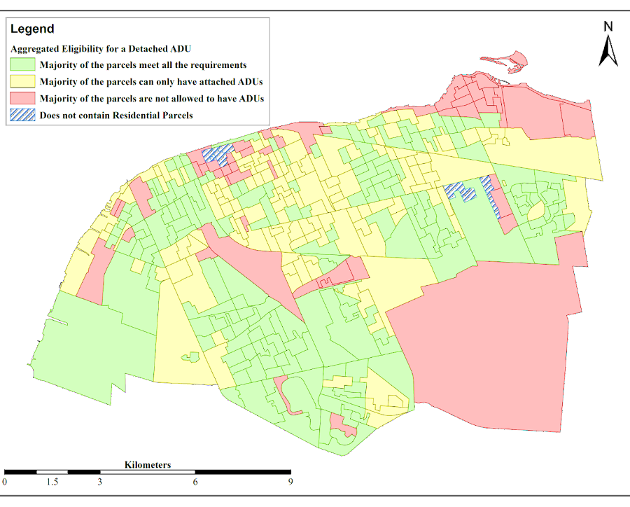
Accordingly, our team was selected to be part of CMHC’s Housing Supply Challenge, to create ADUSearch.ca, an online interactive ADU mapping tool. This proof of concept was produced through the use of GIS and publicly-sourced data and it displays te potential for a zoning by-law-compliant ADU on a lot-by-lot basis at an aggregate level in Windsor. The tool reveals the potential to diversify housing form and tenure to increase the number of rental units in specific neighbourhoods.
Led by a team at the University of Windsor’s Cross Border Institute, comprised of Dr. Hanna Maoh and PhD candidate Terence Dimatulac, the GIS work was focussed on analyzing existing spatial data. Namely residential parcels, building footprints, and road networks were analyzed using publicly sourced spatial data from the City of Windsor’s Open Data Catalogue, to estimate the gross area that could be used to construct an ADU on each parcel in accordance with Zoning By-law 8600, Section 5.99.80. From there, the lot parcels were systematically analyzed to determine the physical feasibility of each individual lot, which is seen in the ‘Property View’ tab of the website.
The parcels were then grouped into three categories (red, yellow, or green) based on whether or not they met the requirements to have the minimum size of a detached ADU in the City of Windsor (40m2). First, “Green Parcels” met all of the criteria and are allowed to have a detached ADU. Those that meet all the non-negotiable criteria but violated one or more of the other criteria belong to the “Yellow Parcels” category. Yellow Parcels would possibly be able to accommodate a detached ADU depending on certain considerations, such as whether there is an existing secondary structure, while also potentially being able to accommodate attached or interior ADUs. Lastly, the parcels that did not meet any of the non-negotiable criteria are categorized as “Red Parcels,” as they cannot accommodate any kind of ADU on their premises.
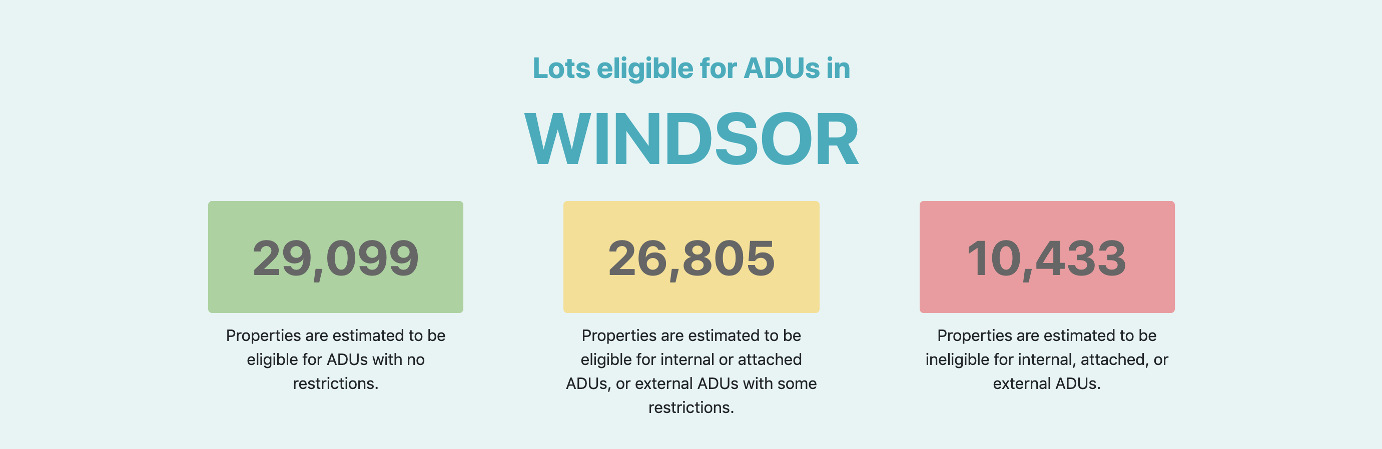
The results for the City of Windsor are significant: there are 29,099 Green Parcels (43.86%), 26,805 Yellow Parcels (40.41%), and 10,433 (15.73%) Red Parcels in Windsor.
These are both viewable at the individual lot level, and aggregated to a Census dissemination area, within the ‘Neighbourhood View’ function of the tool. Additionally, the proof of concept included additional layers to highlight the ‘Proximity to Amenities,’ the Homeowner and Renter Affordability. (These layers used 2016 Census Data and will be updated and remodelled with 2021 Census Data in the next stage.)
The major significance of this proof of concept is its ability to use GIS and spatial analysis to illustrate how the potential for detached ADUs can be estimated for an entire municipality using publicly-available data. Likewise, a standardized categorization system can also be replicated and implemented by other municipalities, facilitating greater congruence and comparative analysis across different jurisdictions. Moreover, the tool demonstrates that if individual properties can have a detached ADU based on municipal by-laws, additional infill potential can be realized at a neighbourhood level (dissemination area), highlighting areas where housing supply can be increased.
In essence, the proof of concept’s outputs address a major challenge in the housing sector by providing the ability for homeowners, policymakers, and researchers to ascertain the physical feasibility of detached ADUs on both a lot-by-lot basis and at an aggregate level. Subsequently, users can compare neighbourhoods by analyzing their ADU capacity in relation to other factors, such as proximity to amenities and affordability for both homeowners and renters. This permits homeowners and policymakers alike to improve decision-making with respect to individual development decisions, in addition to helping them understand the broader policy implications that create, incentivize, or restrict the construction of ADUs. The tool also makes the relevant information publicly available and easier to access, and it simplifies part of the process for the average homeowner, who may not have the knowledge of how to proceed with building an ADU. Indeed, polling of 1000 Ontario homeowners as part of our research confirms the necessity of this data being more accessible, as 43 percent of those surveyed were unclear if an ADU could be constructed on their lot.
Overall, the results from ADUSearch.ca illustrate the potential to increase levels of housing development by recognizing the capacity of existing land in connection with financial and social factors. This tool, designed with a proper online interface, can be used by individual homeowners to better discern where ADUs can be physically located and whether their property is potentially eligible. Furthermore, and perhaps more notably, this tool can be used for policy analysis by municipal decision-makers. Understanding the potential physical feasibility of ADUs would currently be an onerous endeavour for any planning department, and this tool, when scaled nationally, can help to specifically address policy concerns and increase ADU production.
To this end, an automated tool that uses publicly-sourced data allows for a greater assessment of ADU potential, which enables the creation of development incentives and better by-laws to persuade homeowners within existing neighbourhoods. With the ability to determine if some areas are better positioned, physically and financially, to add more ADUs, alongside the right policy incentives, this proof of concept has the potential to transform our built environments through densification that supports many existing residential neighbourhoods in urban and suburban municipalities across Canada.
Sarah Cipkar is a PhD Student in the Planning Department of the University of Toronto. She is currently working with Family Services Windsor-Essex as a Lead Researcher funded by the Housing Supply Challenge to scale ADUSearch.ca nationally.
Shereen Arcis is a 2L Windsor Law student and a Research Assistant of the Centre for Cities. During the summer of 2021 she was a Research Assistant to the ADUsearch.ca project.
In addition to CMHC funding, adusearch.ca was made possible through the support of Family Services Windsor-Essex, the Centre for Cities (Faculty of Law, University of Windsor), and the Cross-Border Institute (University of Windsor). We want to thank and acknowledge the City of Windsor for the use of land parcel and building permit data from their Open Data Catalogue, as well as for their participation in the project. Parallel 42 Systems built the website and map from the assets provided by the GIS team. More details about the project are available here. An online demonstration and discussion of the data tool, presented by Sarah Cipkar and project co-lead Frazier Fathers, is available here.
Main image credit: ADUSearch.ca
Related Articles

Launch of C4C Housing Systems & Innovation Lab
(19 December 2023) The Centre for Cities is pleased to announce the launch of its Housing Systems and Innovation Lab,…

C4C City Building: The First Four Years of the Centre for Cities
(19 December 2023) Read the full report It is our pleasure to present this report on the first four years…
AM800 Citybuilding: Centre for Cities Housing Systems Innovation Lab Launch with Rino Bortolin
(1 November 2023) On this C4C/AM800 Citybuilding segment, our very own Rino Bortolin joined guest host Jon Liedtke to announce…